|
|
||||
|
January 2004 |
||||
|
|
|
By Jean-Yves Kainic, Director of Client Solutions, The TerrAlign Group
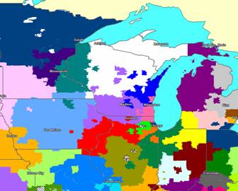
Typical Territory Alignment
On the Front Line With an ever increasing number of field representatives, pharmaceutical companies invest large amounts of time, effort and money to ensure that these field resources find their targets, deliver their message, document their activities and receive appropriate compensation for their work. The field territories are the place where all this support work meets the reality of the market place: the doctors and other healthcare professionals who influence the consumption of healthcare products. As most companies in the field have experienced, designing and maintaining effective territories for their field representatives is a complex and never-ending task. Dedicated technological tools and approaches combined with improved market data are helping companies make this work less time-consuming and more accurate. Yet, many aspects of the work still represent significant challenges to sales administration and field management personnel at companies of various sizes. This article comments on two of these challenges and offers solutions that can be implemented today. One issue is the on-going maintenance of territories. The other is the selection of geographic areas or accounts that should not be covered by field personnel. Territory Maintenance When field organizations redesign territories they typically try to meet these key objectives:
In most cases pharmaceutical companies are successful in integrating these criteria in their new territory alignments. However, after a period of time a review of territories shows a different situation. Territories may not be quite as balanced as they were initially. Some territories may be broken up in multiple pieces, and some ZIP codes or accounts may be isolated. Some ZIP codes may be shared by more than one territory, and some ZIP codes or accounts may be left uncovered. Several phenomena explain these situations:
While each instance of departure from the initial design may have little impact on the overall effectiveness of the territories, when they multiply over time the effect can be noticeable. Many companies have long recognized that sales productivity declines as territory alignments deteriorate over time, and have established systems to overcome the negative impact. A large number of pharmaceutical companies today implement a major review of their territories every 12 to 18 months and allow their field organizations to proceed with “minor” tweaks between major reviews. The “minor” tweaks or on-going maintenance activities present the hardest challenge. In most cases field managers do not have access to the type of dedicated technology that is used by sales administration personnel, either directly or via a consulting company, to manipulate and evaluate territories. Instead, they rely on static maps and lists of doctors or ZIP codes that don't provide a complete picture. As a result, requests for ZIP code or doctor reassignments often don't completely take into consideration the business or geographic impacts. Reviewing each request to insure that the modifications make sense from a business and geographic stand point can be very time consuming for headquarters personnel. In some situations such requests are even entered directly into databases without a complete review. Providing dedicated alignment software to field managers typically creates a new set of challenges: maintaining multiple copies of software, training and supporting multiple users, synchronizing data and alignment files.
The Internet Solution New software offers Internet-based solutions that address many of the difficulties listed above. These applications enable sales administration teams to build and manage territory alignments in a centralized mode, while providing access to field users who can review territories, implement modifications and evaluate these modifications from their office and on their own time. In a real world implementation the solution enables the team members to perform the following tasks:
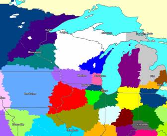
Improved alignments using new Internet applications
This solution enjoys many advantages over more traditional approaches, mainly because of its better balance of central controls and flexible field access:
Focused or Limited Geographic Coverage For large pharmaceutical field organizations calling mostly on generalists, the decision to cover the entire US geography is an easy one. But for companies with limited resources or sales teams calling on a relatively sparse population of specialists the decision is more complex. Should they focus on portions of the country to maximize the efficiency of their representatives and risk alienating physicians in remote areas? If they decide to limit the geographic coverage of their field territories, how should they select those areas that will be assigned to field territories? Should they call on every physician meeting a specific business profile no matter what the travel time requirements may be? If they decide to cover the entire US geography, how should they build territories so that representatives covering more sparse areas are not penalized by higher travel requirements? This is another area in which new applications provide solutions to address these questions. The solutions are based on the use of unique tools that help estimate travel times. Based on advanced mathematical algorithms, these applications estimate the travel time that a representative will incur to visit a physician based on the location and call frequency of that physician and on the locations and call frequencies of neighboring doctors. They can use proprietary driving time networks or can run using straight-line distances. With these state of the art tools, sales administration professionals may enhance their physician databases by calculating a specific average travel time for each doctor in a given population. Travel estimate measures can then be used in a variety of ways to improve the deployment of field sales forces. Consider two illustrations.
These recent developments in territory alignment applications provide managers new flexibility in developing and managing alignments without the associated administrative complexity. New analytical tools significantly improve managers' ability to balance territory workload and travel burdens in order to improve rep efficiency and productivity. •••••
About the Author: Jean-Yves Kainic has been helping health care firms develop and manage sales territories for 15 years. He is currently Director of Client Solutions for the TerrAlign Group, a company that provides sales and marketing services and software -- including territory optimization and territory realignments -- to a wide variety of companies. TerrAlign's eMap and Time Travel Estimator software provide innovative territory alignment solutions to the pharmaceutical, biotech, and medical device industries. If you would like more information about territory alignment software and services, you may contact Jean-Yves Kainic at 888.437.4399, 707 Skokie Blvd., Suite 600 , Northbrook , IL 60062 or at info@terralign.com . You may visit the TerrAlign website at www.terralign.com.
Prior Newsletters To view prior newsletters, please visit our News & Events web page. Subscribe/Unsubscribe Please click here to unsubscribe from the RMCI newsletter. Copyright Notice Copyright 2004, RM Consulting International. All rights reserved. Every viewer may copy, reprint or forward all or part of this newsletter to friends, colleagues or customers, so long as any use is not for resale or profit and the following copyright notice is included intact: "Copyright 2004, RMCI. All rights reserved." Contact Information RM Consulting International |
|
|